Each of us depends on water for nearly all aspects of life. From drinking water, growing food, and producing electricity to manufacturing, recreation, and healthy rivers. Having access to plentiful, clean water is critical to life as we know it.
Where are South Carolina’s (SC) water resources?
SC has many well-known rivers and lakes, also known as “surface waters”, that are present across the state. Most of our surface waters start in the northwest and flow to the southeast, with all of them eventually draining into the Atlantic Ocean. The rain that falls within SC will drain to one of these major rivers – these drainage areas are also called watersheds or basins.
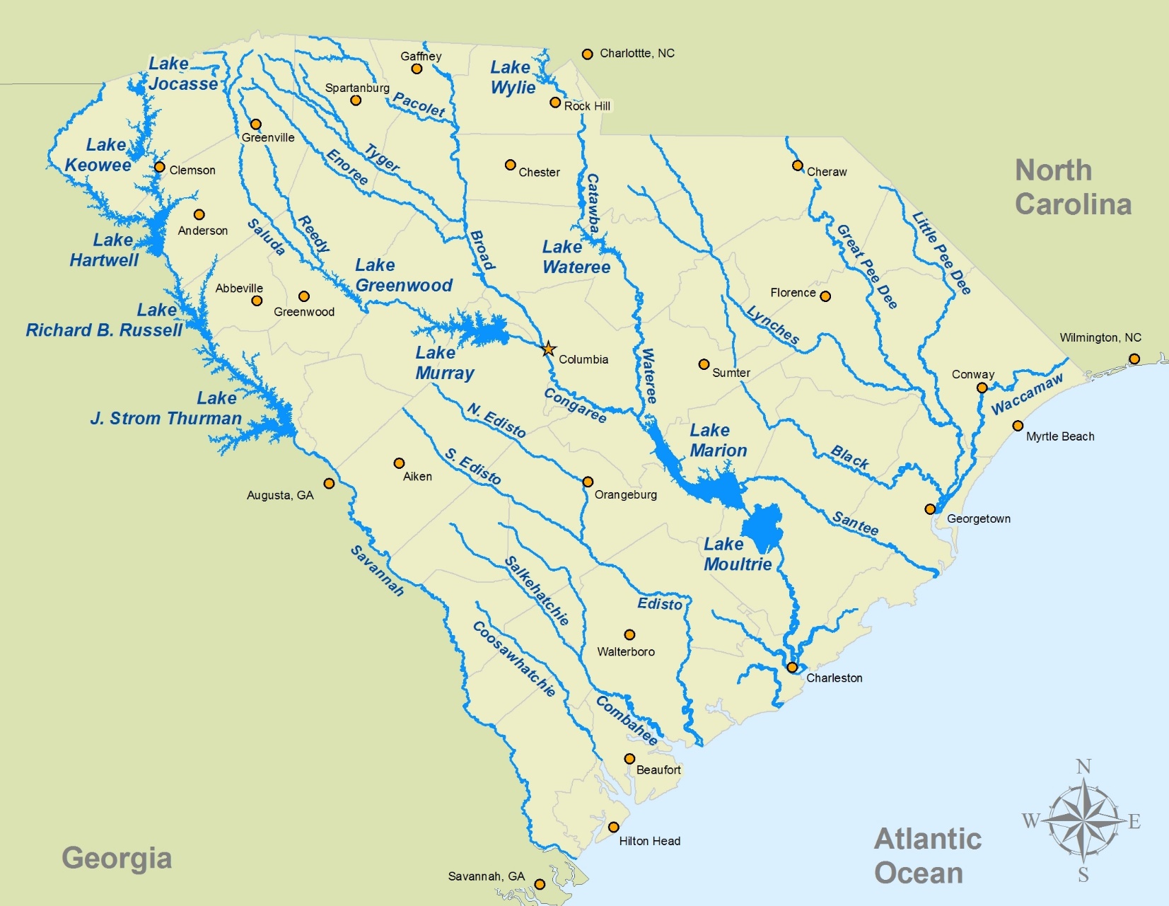
Figure 1. SC’s major rivers and lakes drain into the Atlantic Ocean.
Image credit: SC Film Association.
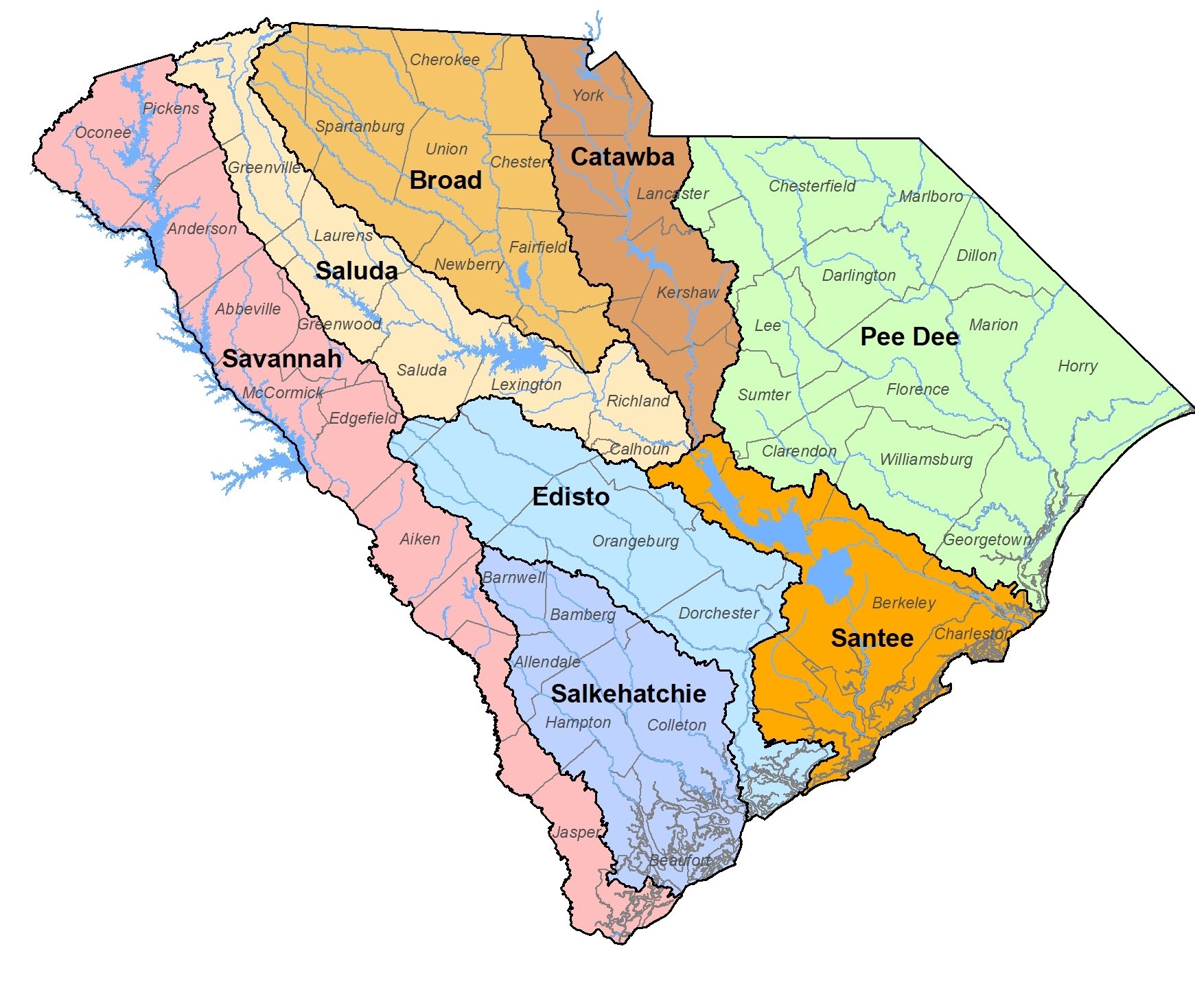
Figure 2. SC has eight major river basins.
Image credit: SCDNR.
Most of SC’s water is actually stored underground – in fact, “groundwater” comprises 99% of our freshwater resources. The Fall Line is a geographic feature that roughly splits SC in half, separating the Piedmont from the Coastal Plain, and runs approximately between Aiken, Columbia, and Cheraw. Nearly all of our groundwater is to the south and east of the Fall Line within the Coastal Plain. SC has several distinct aquifer layers that are separated by clay or rock that limit the movement of water between them.
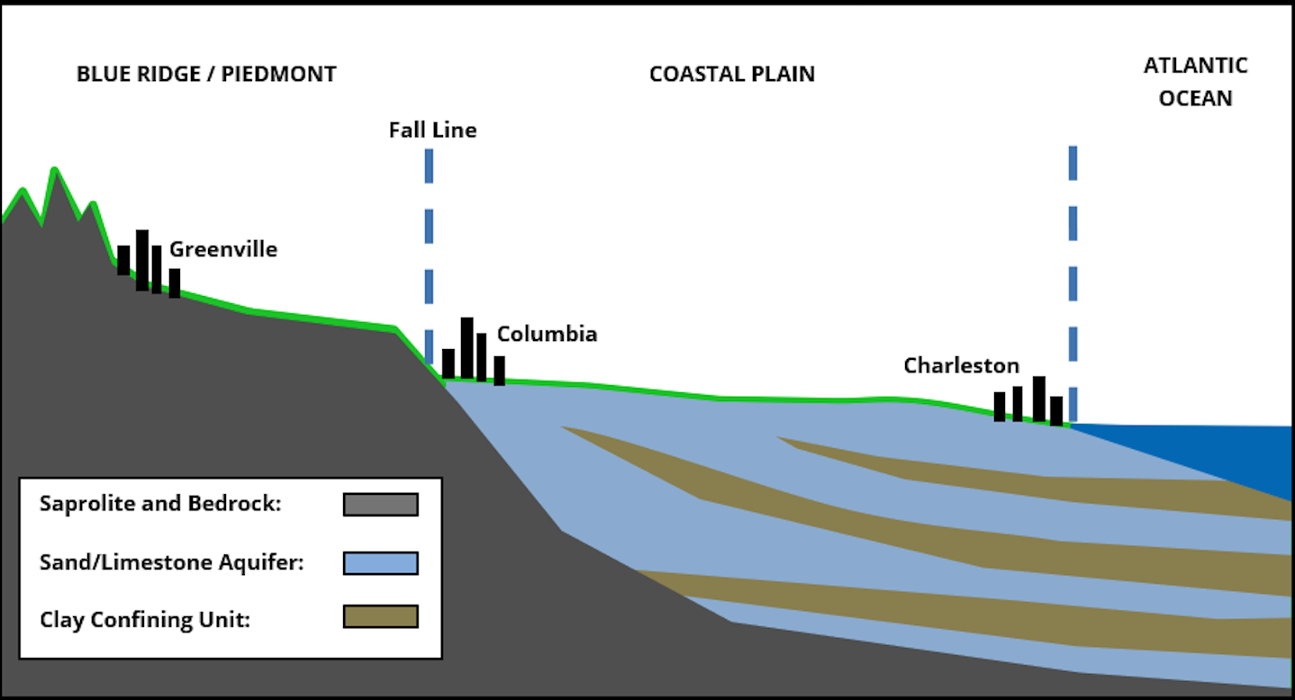
Figure 3. Most of SC’s groundwater is in aquifers to the south and east of the Fall Line. Image credit: Original image SCDNR; edited by Lance Foxworth, SCDHEC.
Who ensures the health of our waterways?
Water is critical to each of our lives, but it’s so readily available we often take it for granted. Fortunately, experts throughout the state are working on planning and managing SC’s water resources to ensure we continue to have plentiful, clean water for future generations.
Two main agencies are involved with overseeing SC’s water resources: the SC Department of Natural Resources (SCDNR) is responsible for planning, management, and resource evaluation; and the SC Department of Health & Environmental Control (SCDHEC) oversees the regulation of water resources, including permitting for water that is either removed from or released into waterways, water quantity monitoring, and water quality monitoring.
How much water do we have in SC?
Relative to some states, SC is thought of as water-rich, receiving a statewide average of 48” of rainfall annually. However, rainfall amounts can vary significantly over time and across the state. For example, in 2016, different regions of SC experienced severe droughts, large wildfires, and significant flooding over just a three-month period.
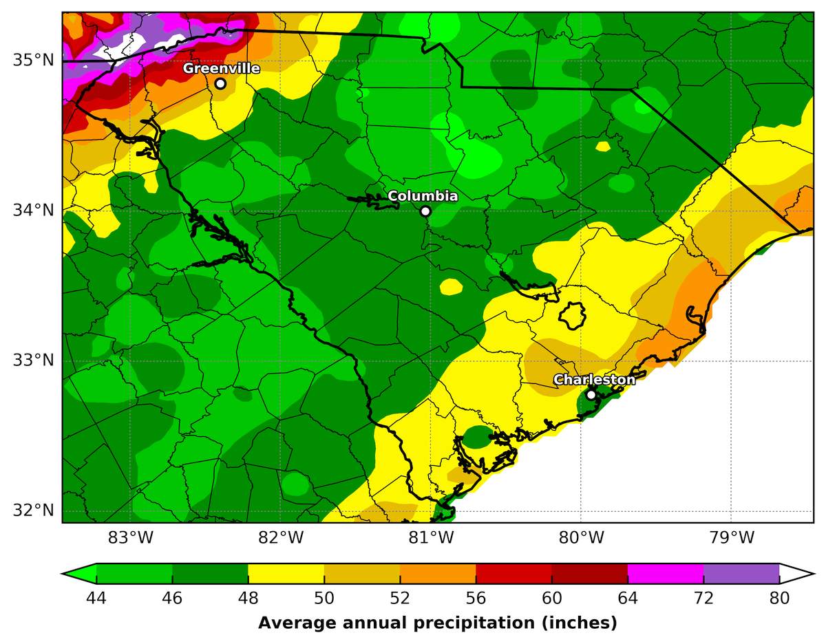
Figure 4. Average annual rainfall levels vary across the state and can range from 44” to 80”.
Image credit: Jordan McLead, Southeast Regional Climate Center.

Figure 5. Drought and flood conditions can change quickly and can vary significantly across the state.
Image credit: Hope Mizzell, SCDNR.
The United States Geological Survey (USGS) monitors surface water flows across the country and maintains more than 100 stream gages in SC. Real-time flow information is available online on the USGS website. SCDNR currently monitors approximately 180 wells to assess groundwater levels, identify trends, and improve management decisions.
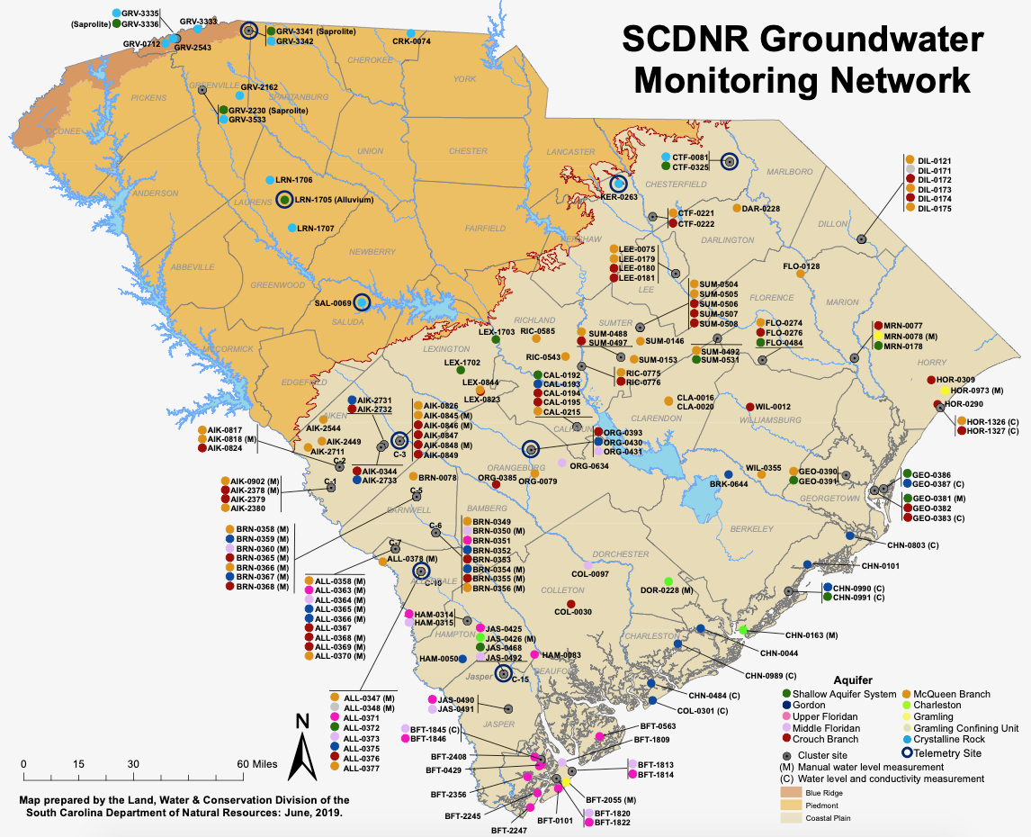
Figure 6. SCDNR focuses most groundwater monitoring efforts below the Fall Line, where the majority of SC’s groundwater is located.
Image credit: SCDNR.
SCDNR periodically compiles the surface and groundwater measurements and summarizes the data in the State Water Assessment and other data reports. Each year, SCDHEC compiles a Water Use Report for the state; a brief summary of the 2018 report is available at HGIC: Water Use In South Carolina.
SCDNR staff also monitor climate data, evaluate trends, and coordinate much of SC’s drought-related work, including the Drought Response Committee, which consists of Agency staff and Governor-appointed members who represent various water interests across the state. Visit Drought.gov to check current drought status or report your drought impacts.
A surface water model was completed for each major river basin in SC to help evaluate how much surface water we have and use. These models include surface water flow volumes, water withdrawals, and water discharges, and can be used to help us determine how much water we can expect at different locations along each major river. The water models for the Edisto, Salkehatchie, and Saluda basins are available online and can be downloaded free of charge. Similarly, a Coastal Plain groundwater flow model also has been developed by the USGS with support from SCDNR and SCDHEC to assess groundwater availability.
How much water do we need?
Moving forward, population and economic growth may increase future water needs. SCDNR collaborated with the SC Water Resources Center at Clemson University and the US Army Corps of Engineers to create a methodology to estimate future water demand for different water users based on current and past water demand. Agency staff members have recently completed water-demand projections for the individual water users within the Edisto basin. These projections will be incorporated into the surface and groundwater models to evaluate future water availability.
Who regulates water use in SC?
On the regulatory side, SCDHEC is responsible for issuing permits and registrations to entities that plan to use a large quantity of water or that will discharge stormwater or wastewater into a waterway.
If an individual, organization, or business expects to withdraw more than three million gallons (3MG) of either surface or groundwater in any month, they must first coordinate with SCDHEC to receive a permit or a registration. SCDHEC staff members evaluate these applications and estimate the probability that the water will be available when and where it is requested. If data shows that water may not be available during critical periods, the permittee may need to identify a back-up source for use during water shortages. This evaluation helps a new water user understand and prepare for anticipated conditions.
Groundwater use is evaluated within each of the Capacity Use Areas throughout the Coastal Plain. SCDHEC leads the development of a plan within each of these areas with the goal of ensuring continued water availability for now and into the future.
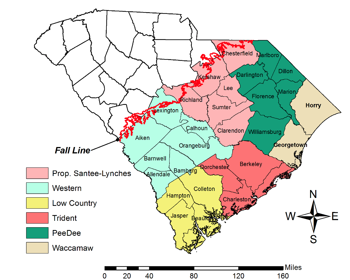
Figure 7. There are six Capacity Use Areas in SC, including the proposed Santee Lynches CUA.
Image credit: Lance Foxworth, SCDHEC.
Related Fact Sheets and Information
- HGIC: Water Use in South Carolina
- HGIC: HGIC 1887, South Carolina’s Water Planning
- SCDNR – Water Planning
- SCDHEC – State Water Plan
- SC Water Resources Center at Clemson University – Stakeholder Website for Water Resources
Originally published 10/20