Who would consider building a house without a blueprint or taking a trip without a road map? Land managers and landowners who are successful at managing wildlife carefully plan and target management activities to accomplish their objectives, minimize expenses, and ensure the long-term productivity of their property for wildlife and other resources. Wildlife management plans are simply written guides for how, when, and where to implement habitat improvement practices. Developing a management plan personally, or contracting a natural resource professional to develop a plan for forest or farm land, is a wise investment of time and money.
Components of an effective wildlife management plan include 1) land management goals and objectives (by priority), 2) a resource inventory, 3) site specific habitat improvement recommendations, 4) a schedule for conducting management practices, and 5) record keeping and evaluation of management efforts and their impacts on wildlife habitat. A carefully developed plan provides a logical approach for using an assortment of habitat improvement practices. Some government cost-sharing programs also require that a management plan be written before cost-sharing funds are provided to landowners.
Steps in Writing a Plan
No two wildlife management plans are exactly the same. Plans vary depending on management objectives, habitat and site characteristics, financial resources, existing land uses (such as forestry or farming), and the individual(s) writing the plan. Assistance for developing and writing plans is available from a variety of sources such as private consulting firms, state Department of Natural Resources (DNR) and Forestry Commissions (FC), some non-governmental conservation organizations such as Ducks Unlimited, National Wild Turkey Federation, and Quail Forever, and the USDA Natural Resources Conservation Service (NRCS). Natural resource professionals from government agencies can provide advice and guidance in developing wildlife habitat management plans at no cost to the landowner. A multi-agency effort, called the Forest Stewardship Program, can also provide management plan assistance for forest owners interested in managing their lands for a diversity of natural resources. In addition to agency assistance programs, natural resource consultants also provide management plan expertise and services for a fee. Consultants should be professionally trained and designated as registered foresters and/or certified wildlife biologists.
Wildlife habitat management plans can be prepared in a variety of ways depending on available resources. Large land management entities often have sophisticated computer programs for recording, analyzing and displaying land use/management information. The advantage of using a computer-based recording and reporting system is that a large amount of diverse information can be quickly updated and easily accessed in a variety of formats (maps, charts, text) for making management decisions. The disadvantage is that these systems are usually cost-prohibitive for the average landowner, although some private consulting firms offer these services. More typically, management plans include a written and visual description (sketch) of the land and other resources with recommendations for habitat improvements.
Whatever the approach, it is important that management plans be usable and flexible documents that guide forest and farm owners toward improving their land for wildlife. The following are important steps that should be considered when developing a sound wildlife habitat management plan:
Step 1. Identify Objectives
Landowners who neglect to identify and prioritize their management objectives are often disappointed with their efforts and results because they never clearly defined what was important or what they wanted to accomplish. As one wildlife manager stated, “If you have no idea where you are going, how do you know when you get there?”
The first and most important step in developing a management plan is to clearly define, in writing, wildlife habitat management objectives and expectations. Objectives should be as specific as possible and include wildlife species to be managed as well as the expected outcome. For example, one objective may be to manage farm or forest land for quality deer with an expected outcome of healthy deer with large antlers and heavy body weights. Habitat improvement practices that improve the abundance and nutritional quality of native and planted deer foods can then be developed and incorporated into the plan to help meet management objectives.
Objectives should also be measurable. This helps in evaluating the success or failure of habitat improvement efforts. Plans that lack measurable objectives are often ineffective, because there is no way to know if management objectives were ever reached. The ability to determine whether or not management objectives were accomplished helps identify successful habitat improvement practices. Plans can then be modified to include only those habitat improvement practices that have successfully met management objectives.
Landowners also need to consider how their wildlife management objectives fit with other land use objectives such as farming or timber operations. Rarely do forest and farm owners have only one land use or management objective. Landowners should prioritize their land use/management objectives to have a clear understanding of where wildlife habitat enhancement efforts fit with other land management operations. In most cases, wildlife habitat improvement practices are compatible with other land management activities. If wildlife and habitat improvements are a top priority, then some concessions and modifications may have to be made in timber, agricultural, or other land uses. Opportunity costs, or potential revenue foregone from other land management operations in favor of wildlife, should be a consideration when prioritizing land management objectives. However, if improving lands for wildlife is a secondary objective, then some concessions in wildlife habitat improvements may have to be made to accommodate other land uses. Defining and prioritizing land management objectives, as well as expected outcomes, helps landowners determine the best approach to managing their lands for wildlife and other resources.
Step 2. Resource Inventory
A resource inventory is the process of identifying, locating, and recording land and other physical characteristics that have a potential to support wildlife or meet other land management objectives. An inventory helps to determine what is already available and what is still needed to meet the objectives. It should include, for example, an assessment of the property and existing habitat, wildlife present on the property, equipment (e.g. tractors, disks, or planters), facilities (e.g. lodging, barns, skinning and equipment sheds), labor requirements (by landowner and others), estimated management expenses and income, cost-sharing options, and sources of technical assistance. Information derived from a resource inventory and/or timber appraisal, in combination with management objectives, is the foundation for selecting and implementing habitat improvement recommendations.
Management plan objectives should be revisited and examined after a resource inventory and may need to be modified, depending on inventory results. A land survey may have revealed management limitations that would make accomplishing certain objectives difficult or unrealistic. The resource inventory may have also identified management opportunities that were not apparent when the objectives were first developed. This is also an opportune time to reexamine personal resources. In light of the resource inventory, are objectives realistic in terms of time and money needed to achieve them? A review of management objectives, inventory information, and financial resources is prudent before selecting the type and intensity of habitat improvement practices.
A Look at the Property: A survey of the property will determine availability and quality of existing habitat and the potential for improvement. A property inventory is a 2-step process that includes 1) identifying physical features (such as land use and vegetative types, water sources, terrain, soils, and other natural and man-made features) from various maps and aerial photographs; and 2) a more detailed in-the-field survey of land features that are not easily identified from maps or aerial photographs. Information from maps, aerial photographs, and field observations should be included as a sketch or computer-generated base map and as a written description in the management plan.
Most land features can be identified using topographical quadrangle maps from the U.S. Geological Surveys, recent aerial photographs from the county USDA Farm Services Agency (FSA) office, soil surveys and soil maps from the county USDA Natural Resource Conservation Service (NRCS) office, and property blueprints (plats) from the county tax assessor’s office. These items are invaluable tools for developing a wildlife habitat management plan. Current color aerial photography can also be found on websites such as Google™ earth, TerraServer, and others. Soil survey information can also be found on USDA’s Web Soil Survey website (http://websoilsurvey.nrcs.usda.gov/app/HomePage.htm). The sketch map and written description should include information from maps, surveys, and aerial photographs such as property location, soil types and capabilities, topography, current land use, vegetative cover types, streams and other water sources, boundary lines, rights-of-ways, road systems, and other important features. If there is too much information to include on one sketch map, separate maps should be drawn. One map could include major features such as soil and vegetation cover types, while a second map could include other pertinent information. Transparent acetate sheets can also be used as overlays on sketch maps to provide additional information on sketches. If a computer and mapping software are available, property and resource maps can easily be created, and then edited and updated as the plan is implemented and conditions change.
The next step is to add additional information to the sketch and written description that could not be identified from resource maps or aerial photographs. This is accomplished by walking over the property with the sketch map and noting unique features that might enhance or restrict wildlife habitat management efforts. Special attention should be given to the presence, arrangement and condition of natural vegetation that provides food and cover for wildlife of interest. Landowners and managers should also note existing timber and mast-producing trees and other vegetation on the property, as well as other areas that could support additional trees, shrubs, grasses, and legumes that benefit wildlife.
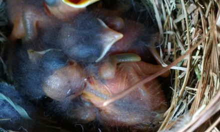
On-the-ground inventories should be made at least twice, at dawn and dusk, because these are peak activity periods for many species of wildlife. Walking over the property during these times helps determine what wildlife species are present on the land. Other signs of wildlife, such as scats or droppings, tracks and travel lanes, feeding areas, beds, nests, dens, burrows, and sounds can also help identify wildlife species that use the land. Special attention should be devoted to determining if threatened or endangered species are present on the property. Sites that support threatened or endangered species should be noted on the sketch map. These areas will require special attention and specific management considerations.

“On-the-ground inventories provide critical information on what wildlife species are found on and around the property and help develop an informed management plan.”
Anthony Savereno, ©2018 Clemson Extension
Equipment & Facilities: Most farm and forest owners have some equipment and facilities that can be used for wildlife habitat improvement practices. A farm tractor can be used for establishing food plots, creating and maintaining fire lanes, and disking natural openings. If no equipment is available, some habitat improvement practices can be contracted out to local farmers and others who own tractors, disks, and planting equipment. Consultants usually have a list of vendors that own management equipment and provide habitat improvement practices. Every effort should also be made to integrate wildlife habitat improvement practices with existing farm and forestry operations to lower costs. The key is advanced planning and coordination with other land management activities.
Existing facilities, such as an old house or barn, are useful for housing management personnel and storing equipment. Labor personnel can stay on the property, while management activities are being conducted, for extended periods to reduce travel and expenses. Old barns and sheds can also be used to store seed, fertilizer, lime, equipment, and other management tools and materials. Barns and old houses can also be refurbished and used as lodging for hunters or other guests.
Financial Considerations: Management expenses depend on objectives, availability of labor and equipment, current land conditions, and whether or not wildlife habitat enhancement practices can be integrated with other land management operations such as forestry or farming. Where possible, wildlife habitat improvement practices should be planned and coordinated with other land management practices to reduce costs and disturbance to wildlife. Management practice costs should be included in the criteria for selecting the level and intensity of wildlife habitat improvement practices. In general, intensive management practices cost more. Management cost for some species of wildlife, like bobwhite quail, that require early successional stage habitat (grasses and forbs), is quite high because of the intensity and frequency of management efforts to maintain habitat at preferred stages. Management practices like prescribed burning and disking may have similar effects on enhancing vegetative growth, but in general, an area can be burned at a lower cost than it can be disked.
Management costs per acre are lowered as they are applied over a larger area. In other words, management costs per acre are lower on large land tracts than on small tracts of land. Management costs can also be reduced if they qualify for cost-sharing assistance. For more information on cost-sharing assistance programs contact the local USDA NRCS or USDA Farm Service Agency office.
Step 3. Designating Management Compartments
Farms and woodlands are seldom uniform in the distribution of plant species, soils, productivity, and management potential. Because of these differences, a variety of management strategies are necessary for enhancing wildlife habitats across an individual farm or forest ownership. Land tracts should be divided up into management units called “compartments” to make the process of recommending and conducting habitat improvement practices over a large and diverse area easier and more efficient. Compartments are areas that have similar characteristics such as vegetation, soils, topography, productivity, or other features. Compartments may be a pine plantation, hardwood stand, swamp, riparian forest, old home site, or any particular field or field system. Because of their uniqueness, compartments can usually be identified from aerial photographs and maps.
Information to Include in a Land Inventory:
- Compartment Number (identifies compartment on land tract)
- Management Objectives (wildlife, timber, and other land uses)
- Location of Compartment
Description of Compartment:
- Size of Compartment (number of acres)
- Soil type(s) and Capabilities
- Site Index
- Drainage
- Aspect
- Dominant Vegetation
Timber Inventory:
- Timber Species Distribution
- Age Classes
- Stand Density (number of trees per acre or basal area)
- Average Sizes
- Timber Volume/Basal Area
- Timber Management History
- Special Trees (number of mast-producing trees, den trees, snags)
Game and Nongame Wildlife Habitats:
- Wildlife Feeding Areas and Plant Composition
- Brush Piles and Windrows
- Nesting Sites and Water
Unique Areas:
- Special Places and Historical Sites
- Threatened and Endangered Species Habitat
Areas Presenting Special Problems and Opportunities:
- Stream Banks
- Streamside Management Zones (SMZ’s)
- Steep Slopes
- Glades
- Coves
- Wetlands
After dividing a land tract into compartments, each compartment’s potential for producing quality wildlife habitat should be evaluated using information from the resource inventory. This information should be used to develop site specific management objectives and recommendations for each compartment. Wildlife habitat improvements should focus first on compartments that have the greatest potential (productivity) for providing wildlife habitat.
Step 4. Selecting Habitat Improvement Practices
After the current conditions and management potential of each compartment are determined, habitat improvement practices should be reviewed and selected for each compartment. Write down practices that would be most appropriate for the land, and then discuss them with a natural resource professional (a certified wildlife biologist or registered forester). When considering management alternatives, be sure to consider the impacts of each practice, timing, costs, and the potential for each practice to complement or conflict with on-going land management operations on the tract and adjacent tracts managed by others.
Compartment Record Sheets: Compartment record sheets (see next page) are vital components of a wildlife management plan. They are standardized information forms (8 1/2”x 11,”3-hole punch) that record compartment management objectives, compartment descriptions, management recommendations, schedules of management activities, and records of management activities and impacts.
Important Tools for Developing a Wildlife Habitat Management Plan
Aerial photographs are used to locate and identify natural and man-made features such as vegetation and forest types, land use, water sources, roads, rights-of-way, buildings, and other features.
They are also useful in delineating management compartments. Aerial photographs are available in black and white, color or color infrared and in various scales. An ideal scale for management plans is 1”= 660’. Aerial photographs can be obtained from the county USDA FSA, county USDA NRCS office or can be contracted to be taken by private natural resource firms. They are also becoming increasingly available online through websites such as Google™ earth.
Topographical maps help to locate property in relation to physical features such as elevation, roads, water sources, and other land characteristics. Topographic maps can be obtained from the U. S. Geological Survey or local map vendors and can also be found online at https://ngmdb.usgs.gov/topoview/viewer/#4/40.01/-100.06
County soil surveys provide a description and map of soil types in a county. Soil surveys also provide soil suitability and productivity ratings for growing timber, producing wildlife habitat, and other land uses. They often include a description of the vegetation on various soil types. Soil surveys can be obtained from the county USDA Natural Resource Conservation Service office or online at the USDA’s Web Soil Survey website (https://websoilsurvey.sc.egov.usda.gov/App/HomePage.htm).
A field notebook and tape recorder are useful for recording observations during the field inventory. Information recorded in the field can be transferred later from field notes and a tape recorder to the management plan.
Field guides are useful for identifying wildlife, trees, shrubs, vines and herbaceous vegetation during the field inventory. Guides with detailed descriptions and color photographs are ideal.
Landscape architecture templates are useful for drawing trees, shrubs, and other natural and man-made features on sketch maps. Templates can be found at most draftsman supply stores.
A camera can be used to document wildlife habitat conditions before and after management practices.
Information from earlier land management plans is invaluable in describing, recommending, and scheduling wildlife habitat improvement practices.
The Process of Developing and Implementing a Wildlife Habitat Management Plan
- Identify Management Objectives for Property
- Conduct Resource Inventory
- Revisit and Modify Objectives (if necessary)
- Designate Management Compartments
- Record Objectives and Descriptive Information by Compartment
- Select Habitat Improvement Practices and Schedule of Activities by compartment
- Implement Management Practices by Compartment
- Record Keeping and Evaluation
- Refine Management Practices Based on Results
Record Keeping and Evaluation
Management plans are dynamic documents that should be evaluated and updated periodically. Evaluations should be made annually for each compartment so that effective practices can continue to be implemented, while those that produce few or no results can be modified or discarded. Recording impacts of management efforts on compartment sheets is important in helping to evaluate the effectiveness of certain management practices. Keeping a log book of observations and changes that occur in compartments can also provide valuable information for evaluating management efforts. Recorded observations should include estimates of vegetative responses to management practices as well as wildlife responses, such as deer and turkey use of food plots. Food plots that are not heavily utilized by wildlife in one area should be discontinued and moved to more suitable sites after an appropriate amount of time to allow wildlife to accept them. There is no substitute for good record keeping as a basis for evaluating the effectiveness of wildlife management practices.
Additional Wildlife Habitat Management Plan Considerations
- Where possible, integrate wildlife habitat improvement practices with other land management such as forestry or agriculture. If conducted properly, most silvicultural practices are also good wildlife habitat improvement practices and vice versa. Examine existing forest and farm management plans and modify them to include practices that also benefit wildlife. Wildlife habitat improvement practices should be an integral part of a total forest or farm master plan.
- Landowners should know the types and condition of wildlife habitat and current management practices on neighboring lands. In some cases, neighboring land use/management may complement the objectives. Management practices, such as prescribed burning, can be conducted jointly with neighbors. Adjacent property may also provide habitat components not found on the land. Whenever possible, planning, development, and implementation of wildlife habitat improvement practices should be coordinated with neighboring landowners.
- Management plans (forestry, farming, and wildlife) should be shared with user groups such as hunters, horseback riders, and other outdoor enthusiasts, especially if these groups pay an access fee to the property. Informing user groups of land management objectives and future management activities reduces potential conflicts and misunderstandings. User groups that are aware of management activities may also be willing to donate labor, such as hunters who may be interested in establishing and maintaining food plots or wildlife openings.
- Game population objectives and harvest strategies should also be included in the management plan.
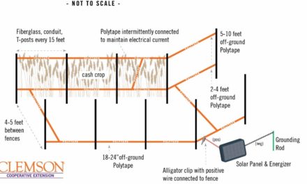
- Nuisance wildlife problems (such as beavers or depredating deer) and control methods should be included in the management plan. Controlling nuisance wildlife requires a detailed plan of action.
- Technical assistance should be sought from consultants or agency professionals to design and implement a wildlife management plan. Natural resource professionals should ideally be registered foresters or wildlife biologists certified by The Wildlife Society.
Format for a Simple Wildlife Habitat Management Plan
The following is a suggested format for organizing a management
plan into a three-ring loose-leaf notebook. This makes it easier to add materials to the plan. At a minimum, the plan should contain the 6 sections below. These sections can be marked in the notebook with colored index tabs for easy access:
- General Description of the Entire Property: Includes a brief description of the entire property such as location in the county, number of acres, past and current land uses, general forest and vegetation conditions, and number of compartments.
- Land Use and Management Objectives: Includes a priority listing of wildlife and other land use and management objectives. This section should also include a brief index of each compartment’s management objectives.
- Sketch Map: Provides a visual description (sketch) of the property. May include several maps such as 1) a base map that shows boundaries, roads, and other man-made features; 2) a type map that differentiates cover types (timber stands, agricultural fields, and open fields); 3) a soils map that shows the location of different soil types; and 4) a compartment map that indicates where habitat improvement practices have or will take place.
- Compartment Record Sheets: Contains descriptive information and wildlife habitat improvement recommendations for each compartment. Also includes a schedule of recommended management activities for the compartment for a 10-year period.
- Field Notes Section: Provides a commentary of impacts of management activities and wildlife observations taken directly from log books and archived in the three-ringed binder. The most appropriate method for storing field notes is by compartment.
- Resource Materials Section: Contains copies of aerial photographs, topographic and soil maps used to draw the base map. This section should also include reference materials such as bulletins, leaflets, and articles on wildlife habitat management. The names, addresses, and telephone numbers of resource professionals who helped prepare the management plan and who will be conducting management practices should be included here.
Compartment No.______________________________
Management Objectives (includes priorities for wildlife, timber and other land uses)
Wildlife____________________________________________________________________________________________________________________________________________________
Timber_____________________________________________________________________________________________________________________________________________________
Other______________________________________________________________________________________________________________________________________________________
Location of Compartment_______________________________________________________________________________________________________________________________________________
_____________________________________________________________________________
Description of Compartment (Narrative description of compartment) _______________________________________________________________________________________________________________________________________________________________________________________________________________________________________
Size of Compartment ____________________________acres
Compartment Characteristics:
Soil type and capabilities___________________
Drainage________________________________
Tree species composition___________________
Trees per acre___________________________
Mast-Producing Trees_____________________
Fruit-bearing shrubs & herbaceous plants__________________________________
Den Trees & Snags________________________
Specific wildlife habitat information_______________________________Site index_________________________
Aspect___________________________
Volume/basal area of timber__________
Mean DBH (diameter of tree at breast height)___________________________
Activities to be conducted (in a calendar year from start to finish)
1.
2.
3.
4.
5.
6.
7.
8.
9.
10.
Record of wildlife, timber and other management activities:
Activity Year
Impact of Management Activities_____________________________________________________________________________________________________________________________________________________________________________________________________________________________________________________________________________________________________________
Originally published 08/18